

Dr. Vogelgesang Gorge


- pets allowed
- Suitable for families
- Flatly
- Possible accommodation
Interactive elevation profile
Create PDF
Tour-Details
Paths covering:
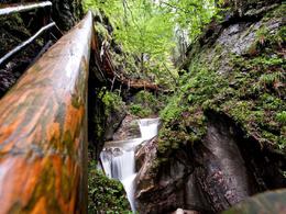
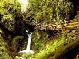
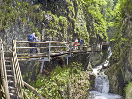
A wild romantic gorge with a doctor’s title – the LONGEST GORGE IN UPPER AUSTRIA & THE SECOND LONGEST GORGE IN AUSTRIA!
The Dr. Vogelgesang-Gorge is a welcome destination for all ages, from infant to old age. At the end you ...
further information:
- Flatly
- Possible accommodation
- Board possible
Details - hiking
- themed path
Open from May 1st to October 31st
on weekdays 7.30am to 6.00pm
on Sat, Sun and public holidays from 7:00 to 18:00

Attention: From the motorway exit, drive without a sat nav - this will usually lead you to the wrong gorge!
On the A9, the Pyhrn motorway, take the Spital am Pyhrn exit and turn left. Drive through the centre of Spital am Pyhrn. 100 metres after the end of the village (just before the Panorama indoor pool), turn right into Sandstraße and follow the signs along the Trattenbach stream to the Grünau district (approx. 2km).
Or via the B138 from Windischgarsten towards Spital am Pyhrn, after the Panorama indoor pool turn left into Sandstraße and follow the signs along the Trattenbach stream to the Grünau district (approx. 2km) follow the signs.
Public
Take the ÖBB Postbus (line 911) or the Postbus (line 430) to the Spital am Pyhrn Hauptplatz stop - walking time to the gorge entrance approx. 30 min.
- Parking space: 150
The car parks at Dr Vogelgesangklamm are subject to a charge.
Clamp maintenance fee:
- Adults: € 6.30
- Children (6-15 years): € 4.20
- Children
Children from 6 to 15 years: € 4.20 - Student groups with school class
School groups up to the 15th birthday (from 10 persons): € 3.60 - Handicapped
with ID: € 5,30 - Families
Family ticket: When accompanied by at least one full-paying adult and showing the family ticket, children only pay € 3.60
Family rate: With 2 full-paying adults, children pay only € 3.60 - Groups
Groups adults (from 20 pers.): € 5,70
- Pyhrn-Priel-Card
Free entry, as often as you like - Phyrn-Priel seasonal pass
Free entry, as often as you like
- Suitable for groups
- Suitable for schools
- Pets allowed
- Suitable for teenagers
- Suitable for seniors
- Suitable for single travelers
- Suitable for families
- Suitable for friends
- Suitable for couples
- Suitable for children
In wet weather the wooden steps are slippery!
Wooden footbridges and wooden steps that are open at the back run through the gorge. Many small children manage to hike through the gorge, but for some it is too much.
Dogs are allowed in the gorge, but you have to judge for yourself whether the dogs dare.
- Spring
- Summer
- Autumn
Not suitable for wheelchairs. The property is not compliant with Austria's ÖNORM legal standard.

Interactive elevation profile
Create PDF
Tour-Details
Paths covering:


