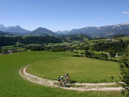
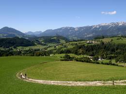
Oberwenger panoramic route MTB2


- Flatly
Interactive elevation profile
Create PDF
Tour-Details
Starting place: 4582 Spital am Pyhrn
Destination: 4582 Spital am Pyhrn
duration: 1h 54m
length: 15,7 km
Altitude difference (uphill): 709m
Altitude difference (downhill): 705m
Lowest point: 656m
Highest point: 1.217m
difficulty: easy
condition: medium
panoramic view: Great panorama
Paths covering:
Asphalt, Gravel
powered by TOURDATA
Spital am Pyhrn - Oberweng - Großhütte - Sonnleitner Schottergrube - Holzeralm - Gowilalm crossroads - Flinderlmühle - Oberweng - Spital am Pyhrn
Starting point: Parking lot indoor swimming pool in Spital am Pyhrn
Destination: Parking lot indoor swimming pool in Spital am Pyhrn
further information:
- Flatly
- Board possible
details mountainbike
- Riding technique: easy
Cycling and mountain biking is permitted from April 15 to October 31, 2 hours after sunrise to 1 hour before sunset, and is only permitted on marked routes. Some bike paths are also designated as hiking trails or bridle paths. Always be prepared for oncoming hikers or riders!
Accessibility / arrival
The starting point is the parking lot at the indoor swimming pool in Spital am Pyhrn.
- Suitable for groups
- Suitable for seniors
- Suitable for single travelers
- Suitable for friends
- Suitable for couples
- Spring
- Summer
- Autumn
Please get in touch for more information.

Stiftsplatz 1
4582 Spital am Pyhrn
Phone +43 7563 249
Fax machine +43 7563 249 - 20
E-Mail spital@pyhrn-priel.net
Web www.urlaubsregion-pyhrn-priel.at
https://www.urlaubsregion-pyhrn-priel.at

")
")
")
")
Interactive elevation profile
Create PDF
Tour-Details
Starting place: 4582 Spital am Pyhrn
Destination: 4582 Spital am Pyhrn
duration: 1h 54m
length: 15,7 km
Altitude difference (uphill): 709m
Altitude difference (downhill): 705m
Lowest point: 656m
Highest point: 1.217m
difficulty: easy
condition: medium
panoramic view: Great panorama
Paths covering:
Asphalt, Gravel
powered by TOURDATA


