Accommodation Booking
Arrival
Departure:
search
Search
Close

Steyrsbergerreith - Hutterer Böden

Steyrsbergerreith - Hutterer Böden
Ein Produkt der hubermedia GmbH

 Interactive elevation profile

Download GPS data
Create PDF

Tour-Details

Path number: 11
Starting place: 4574 Vorderstoder
Destination: 4573 Hinterstoder

duration: 3h 15m
length: 7,0 km
Altitude difference (uphill): 656m
Altitude difference (downhill): 192m

Lowest point: 915m
Highest point: 1.400m
difficulty: medium
condition: medium
panoramic view: Great panorama

Paths covering:
Gravel

powered by TOURDATA

roadblock: Redlstein closed

Description: Hiking trail no. 11/31 and MTB 3 are closed until further notice due to an acute risk of rockfall in the Redlstein area! From May 10 to 27, 2025, rock clearance work will take place and there is a danger to life!


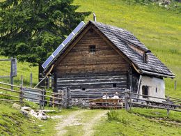
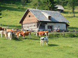
This beautifully situated alpine hut surrounded by alpine pastures is managed during the summer.

From Baumschlagerberg in Vorderstoder the trail leads over meadows first then up through a forest, crossing a forest road until you get to a second forest road taking you to turn off (HT) and further to your right to the soon visible Steyrsbergerreith pasture.

The trail to the Hutterer Böden in Hinterstoder continues on a flat path, reaches a forest road (from here markings nr. 31), which you follow until you get to a fork in the road (the road to the left leads to ...

 Interactive elevation profile

Download GPS data
Create PDF

Tour-Details

Path number: 11
Starting place: 4574 Vorderstoder
Destination: 4573 Hinterstoder

duration: 3h 15m
length: 7,0 km
Altitude difference (uphill): 656m
Altitude difference (downhill): 192m

Lowest point: 915m
Highest point: 1.400m
difficulty: medium
condition: medium
panoramic view: Great panorama

Paths covering:
Gravel

powered by TOURDATA
Protected by