© Winter panorama on the Wurzeralm | Photo: Oberösterreich Tourismus GmbH / Moritz Ablinger
A view from the ski slope on the Frauenkar to the Wurzeralm and a sunrise in the background.
Accommodation Booking
Arrival
Departure:
<zurückVor>
Mai 2025
MoDiMiDoFrSaSo
   1234
567891011
12131415161718
19202122232425
262728293031 
search
Search
Close

Rohrauerhaus Mountain biking trail MTB9

  • Suitable for families
  • Possible accommodation

 Interactive elevation profile

Download GPS data
Create PDF

Tour-Details

Path number: MTB 9
Starting place: 4582 Spital am Pyhrn
Destination: 4582 Spital am Pyhrn

duration: 2h 36m
length: 17,9 km
Altitude difference (uphill): 750m
Altitude difference (downhill): 750m

Lowest point: 655m
Highest point: 1.329m
difficulty: medium
condition: medium
panoramic view: Great panorama

Paths covering:
Asphalt, Gravel, Hiking trail, Other

powered by TOURDATA

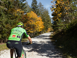
By mountain bike via part of the Spitaler Panoramatour to the Rohrauerhaus.
Short but crisp mountain bike tour with a small single trail (category red).


The mountain bike tour starts at the indoor swimming pool car park in Spital am Pyhrn and first leads to the Jugendparadies Lindenhof. After the fork, turn left and then left again immediately after the railway subway. Now follow the road, which then turns right into a gravel road before you come back to tarmac above and have to turn left.

Now follow the road which leads past the Pantl spring, where the Spital drinking ...

 Interactive elevation profile

Download GPS data
Create PDF

Tour-Details

Path number: MTB 9
Starting place: 4582 Spital am Pyhrn
Destination: 4582 Spital am Pyhrn

duration: 2h 36m
length: 17,9 km
Altitude difference (uphill): 750m
Altitude difference (downhill): 750m

Lowest point: 655m
Highest point: 1.329m
difficulty: medium
condition: medium
panoramic view: Great panorama

Paths covering:
Asphalt, Gravel, Hiking trail, Other

powered by TOURDATA
Protected by