© Foto: Pyhrn-Priel Tourismus GmbH/Markus Kohlmayr | Skifahren in Hinterstoder auf der Höss in der Urlaubsregion Pyhrn-Priel.

© Foto: Pyhrn-Priel Tourismus GmbH/Markus Kohlmayr | Skifahren in Hinterstoder auf der Höss in der Urlaubsregion Pyhrn-Priel.

Give yourself mountains...
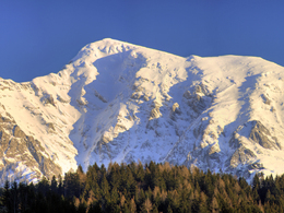
Großer Pyhrgas of the Bosruckhütte


- Possible accommodation
Interactive elevation profile
Create PDF
Tour-Details
Path number: 615, 614
Starting place: 4582 Spital am Pyhrn
Destination: 4582 Spital am Pyhrn
duration: 6h 33m
length: 9,1 km
Altitude difference (uphill): 1.195m
Altitude difference (downhill): 1.194m
Lowest point: 1.045m
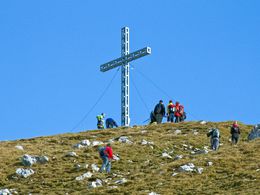
Highest point: 2.221m
difficulty: difficult
condition: medium
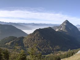
panoramic view: Great panorama
Paths covering:
Climbing mount, Gravel, Hiking trail
powered by TOURDATA
information: Akutmeldung/Information
Description: Due to the increased risk of falling rocks and the generally brittle rock, we recommend that you only walk the Hofersteig (path no. 615) with a helmet! Surefootedness, a head for heights and a good physical condition are required. A rest in the particularly endangered areas should be avoided.
Hike of the Bosruckhütte to Rohrauerhaus and on the Hofer climbing trail to the Großer Pyhrgas.
You soon reach the Pyhrgasgatterl, through which the Styrian-Upper Austrian border runs. Follow the border northwards along the Hofersteig trail (trail no. 615 - please wear a helmet due to the risk of falling rocks), initially through wooded ...
Starting point: Bosruckhütte in Spital am Pyhrn
Destination: Bosruckhütte in Spital am Pyhrn
further information:
- Possible accommodation
- Board possible
")
")
")

Accessibility / arrival
Leave the A9 at Spital am Pyhrn and enter the village via the B138. After the ADEG supermarket turn right into Sandstrasse and follow the signs to Dr. Follow Vogelgesangklamm. In Grünau, follow the supply road to the Bosruckhütte to the parking lot.
Most economical season
- Spring
- Summer
- Autumn
Please get in touch for more information.

Interactive elevation profile
Create PDF
Tour-Details
Path number: 615, 614
Starting place: 4582 Spital am Pyhrn
Destination: 4582 Spital am Pyhrn
duration: 6h 33m
length: 9,1 km
Altitude difference (uphill): 1.195m
Altitude difference (downhill): 1.194m
Lowest point: 1.045m
Highest point: 2.221m
difficulty: difficult
condition: medium
panoramic view: Great panorama
Paths covering:
Climbing mount, Gravel, Hiking trail
powered by TOURDATA


